Every question answered.
The ultimate footbridge FAQ.
General Questions
Recreation, trails, and equitable access
Location
Legality
Opposition campaign
Environment
Logistics and dogs
Connect Bend
General Questions
What’s specifically being proposed?
BPRD has proposed a bicycle and pedestrian bridge connecting sections of the Deschutes River Trail on the east and west side of the Deschutes River, providing access from southern Bend neighborhoods to the Deschutes National Forest.
(Top)
Give me a history of this whole issue
In 2012 residents of Bend voted in favor of Measure 9-86, a $29 million BPRD bond funding several projects, including this footbridge. The measure passed, with 52.11% of voters in favor and 47.89% against.
This bond prioritized completion of the Deschutes River Trail from Tumalo State Park to Sunriver “with connections to US Forest Service Trails” and including construction of “pedestrian crossings connecting the east and west sides of the River Trail.”
To review exactly what voters approved, see the official Voters’ Pamphlet (scroll to page 5).
In 2015 BPRD studied five potential bridge locations based on criteria including riparian impact, distance to public trails or parks, need for easements, land ownership, visibility to existing properties, and location in relation to BPRD boundaries. Based on these criteria, a site on Forest Service land just outside the Bend UGB was selected.
In 2017 residents of a private community on Bachelor View Road, immediately adjacent to the Good Dog-Rimrock Trailhead area, began a Salem campaign to ban bridges at the selected location. Opponents worked with Rep. Gene Whisnant (R-Sunriver) in a “gut and stuff” effort that failed in the State Senate (House Bill 2027).
A BPRD poll of 532 households that same year found 72% of Bend residents were in favor of the project, with 13% opposed.
In 2018 the group Oregon Wild joined the Bachelor View Road effort to pursue a second legislative ban effort (House Bill 4029). The proposed legislation did not make it to the floor for a vote.
Following these failed legislative efforts, BPRD’s board of directors voted in 2019 to “deprioritize” the project, removing it from their budget. The footbridge remained in BPRD’s Comprehensive Plan.
Connect Bend formed that year, with the goal of sharing factual information related to the proposed footbridge, increasing outdoor access in underserved Bend neighborhoods, and advocating for a footbridge connecting southern Bend neighborhoods to the Deschutes National Forest.
In 2023 BPRD enlisted RRC Associates to conduct a new, independent poll with 840 respondents, finding that 71% supported completion of “a footbridge crossing of the Deschutes River, which would connect the Deschutes River Trail on the south end of Bend to the Deschutes National Forest, near the Rimrock Trailhead,” with just 11% opposed. Among residents of southern Bend (south of US 20) support rose to 76%, with only 10% opposed.
In February 2025, the BPRD board of directors voted 5-0 “to direct staff to collaborate with stakeholders and the community to develop and evaluate alternative trail alignments to connect the southern portion of the Deschutes River Trail to the Deschutes National Forest.” This project, the Deschutes River Trail South Study, began in early 2026 and provides multiple opportunities for public input.
As part of this work, Kittelson and Associates, the engineering firm leading the study, will identify two preferred footbridge sites, one of which may use existing crossings. Kittelson will provide cost estimates and preliminary designs for the two sites, along with a review of right-of-way acquisition needs, environmental impacts, mitigation needs, and permitting requirements. More detailed information, including a timeline, is available at the study website.
This project has been included in area planning documents for more than 25 years, dating back at least to the 1996 City of Bend Urban Trail Plan, and appearing most recently in the BPRD Comprehensive Plan 2024 Midterm Update.
(Top)
Did Bend pay for the footbridge?
Bend voters funded the project as a part of 2012 bond Measure 9-86, which raised $29 million from taxpayers within the Bend Park and Recreation District.
The 2012 Voters’ Pamphlet repeatedly prioritizes completion of the Deschutes River Trail, including additional pedestrian crossings to connect the east and west sides of the river, making direct reference to a future footbridge connecting the section of the Deschutes River Trail on the west side of the river in the Deschutes National Forest to the river’s east bank. These elements align fully with the proposed footbridge.
While BPRD did redirect bond funds to other projects, funding for a bridge has not been “used up,” as is sometimes claimed. Bond funds must be spent within a defined period and, accordingly, cannot be tied to a single project indefinitely.
Most importantly, BPRD has publicly stated its willingness and ability to fund this project, and members of the Board have acknowledged that this project is directly aligned with what voters endorsed when they approved Measure 9-86.
(Top)
Is the bridge project legal? (Yes, short answer.)
Yes, without question. However, in some locations an administrative rule (OAR 736-040-0073.1-2) associated with Oregon’s State Scenic Waterways Act would require a landowner to wait a year (ORS 390.845) after proposing a footbridge before starting construction. See a more detailed explanation below.
(Top)
Who would benefit?
Approximately 20,000 Bend residents live in areas that would receive vastly improved access to the Deschutes National Forest. We view these areas to be Southwest Bend, Southeast Bend, the southern half of the Old Farm District, and the Deschutes River Woods.
Deschutes River Trail planning images from BPRD. Click to enlarge.
Recreation, Trails, and Equitable Access
Is this footbridge needed to complete a Deschutes River Trail from Tumalo State Park to Sunriver?
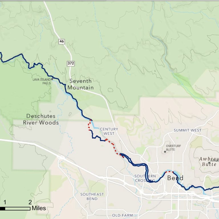
Yes. The completed trail would begin at Tumalo State Park, pass through Riley Ranch Nature Reserve, cross over to the west shore of the Deschutes, return to the east at Pioneer Park, and pass through downtown Bend and the Old Mill District. It would then continue south on the existing Deschutes River Trail on both sides of the river until reaching the existing Conley Brooks Bridge.
At that point the trail would continue up the canyon on the east side and connect to Central Oregon Irrigation District (COID) property where it currently follows shared “ditchrider” roads between the river and irrigation pipe. Leaving the COID property, the trail would briefly follows public sidewalks to a path through River Rim development. These paths have a “public use overlay” and are therefore open to the public.
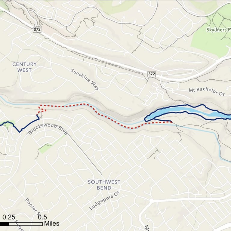
The existing River Rim trails allow the Deschutes River Trail to extend to city limits at the south end of the Bend Urban Growth Boundary. The proposed footbridge would then link this trail to Rimrock Trailhead and Meadow Camp Picnic Area, after which the existing trail passes Dillon and Benham Falls, continuing to Sunriver.
A map of the portion of the Deschutes River Trail in southern Bend with needed connections clearly indicated is available here.
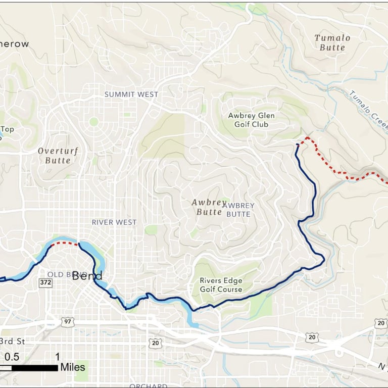
In addition to this southern crossing, BPRD will need to complete an additional river crossing from near Awbrey Butte to the Riley Ranch Nature Reserve in order to provide a continuous Deschutes River Trail from Tumalo to Sunriver.
See our aerial video for more context.
(Top)
How would the footbridge impact commute time to outdoor areas?
Connect Bend calculated commute times from three areas in southern Bend – a point in River Rim, a point in the Deschutes River Woods, and the intersection of Baker Road and Highway 97 – to the Deschutes National Forest.
Average round trip journey is 17.4 miles, with travel to and from the Deschutes National Forest passing through congested areas of Reed Market Road.
These three sites in southern Bend are an average of one mile from the footbridge site. Upon completion of a footbridge in this area a significant drive would be replaced by a short commute by bike or foot, eliminating many auto trips altogether.
(Top)
Does southern Bend have parks? Will the bridge lead to more equitable outdoor access?
Southern Bend and the Deschutes River Woods are the two most underserved neighborhoods in Bend in terms of outdoor access, according to our study here.
Bend neighborhood parks near the proposed bridge site are small. Here is a rundown (all values approximate):
Wildflower Park = 3.2 acres
Hollygrape Park = 3 acres
River Canyon Park = 1.2 acres
Renaissance Ridge Park = 2.1 acres (private, not a BPRD park)
Pine Ridge Park = 2.7 acres
River Rim Park (open space but undeveloped) = 3.6 acres
Cinder Cone Natural Area = 3.7 acres
An additional significant concern is the nearby Deschutes River Woods neighborhood, which has no public parks.
Average round-trip commute from southern Bend to the Deschutes National Forest is 17.4 miles (see above). When complete a footbridge would almost entirely eliminate this commute.
(Top)

Location
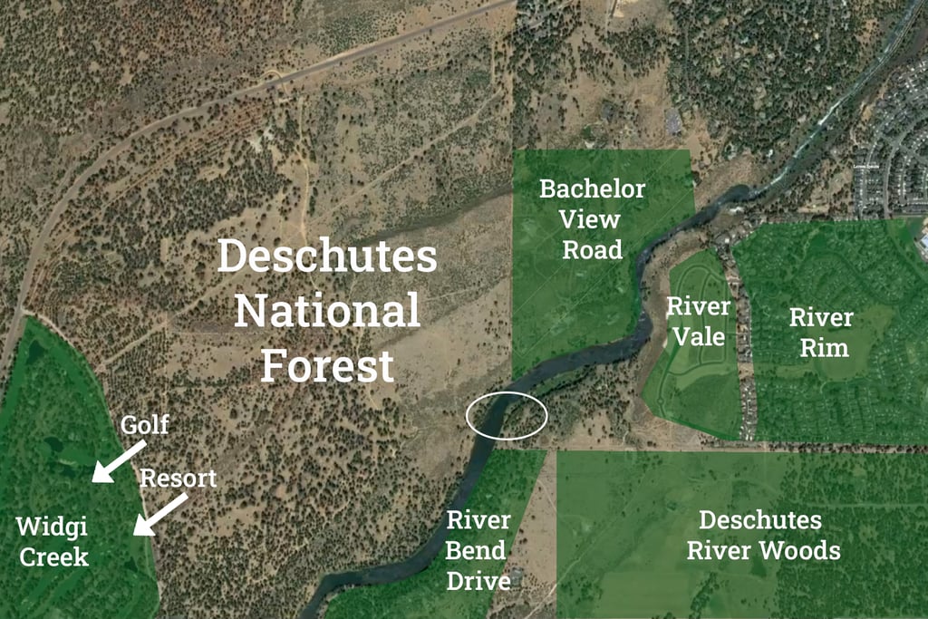
Where will the bridge be located?
BPRD’s Deschutes River Trail South Study will develop engineering and environmental studies for two sites in a study area that extends from the Bill Healy Bridge into the Deschutes National Forest. This study will be complete in early 2027. For updates – including opportunities to share your ideas for the study – sign up for BPRD’s email list at the study website.
In an earlier effort to identify a footbridge site, BPRD’s board of directors selected a footbridge site in the Deschutes National Forest adjacent to Bend’s UGB. Here is a Google Map link of the approximate landing site on the western shore. This is the last proposed site.
Our aerial footage video seeks to help residents understand and contextualize the area surrounding the last-proposed footbridge location.
(Top)
Is this area developed?
The bridge site area is developed on three sides, with the only undeveloped area being the Deschutes National Forest itself. The three neighborhoods closest to the bridge site are:
Bachelor View Road, a private community on the west side to the north of the last proposed bridge site. 42 parcels covering approximately 170 acres.
River Rim and River Vale, east side to the north of the last proposed bridge site. Total 585 parcels.
River Bend Estates (River Bend Drive), closest to the last proposed bridge site. Total 84 parcels.
Our aerial footage video seeks to help residents understand and contextualize areas surrounding this potential site.
(Top)
How many people live in the affected areas?
According to 2020 census figures, approximately 20,000 people live in the neighborhoods of Southeast Bend, Southwest Bend, and the Deschutes River Woods. Residents in the Old Farm District, especially its southern half, would benefit as well.
The white circle below indicates the last-proposed footbridge site.
Authorization and Legality
Is the footbridge project the democratic will of the people of Bend?
Is the footbridge project the democratic will of the people of Bend?
Bend voters approved of bond Measure 9-86 in 2012, with 52.11% voting in favor and 47.89% against. The official Voters' Pamphlet is here (scroll to page 5).
In keeping with a standard practice, the language of 9-86 was phrased broadly:
“Shall BPRD protect natural areas, connect trails and improve parks by issuing up to $29 Million in General Obligation Bonds? If the bonds are approved, they will be payable from taxes on property or property ownership that are not subject to the limits of sections 11 and 11b, Article XI of the Oregon Constitution, ORS250.037(1)[1][2].”
In the Voters’ Pamphlet this broad proposition is immediately followed by a “summary” listing the specific projects that the bond would fund if approved. This summary explicitly names completion of the Deschutes River Trail. Following the summary section, the pamphlet defines what completing the Deschutes River Trail means in relation to the bond:
“The River Trail would extend from Sunriver to Tumalo State Park with connections to US Forest Service Trails and would provide (a) public access to Gopher Gulch Community Park; (b) additional connectivity through the land adjacent to Gopher Gulch Community Park; (c) a new trail along 3 plus miles of the Deschutes River; (d) pedestrian crossings connecting the east and west sides of the River Trail; and (e) improved trails linking the River Trail to downtown Bend and Pioneer Park” (emphasis added).
In sum, when Bend voted for bond Measure 9-86, they voted for this proposition.
(Top)
Is the footbridge project legal? (Yes, longer answer)
The footbridge location proposed by BPRD in 2015 is regulated by the federal Wild and Scenic Rivers Act and Oregon’s State Scenic Waterways Act. Both Acts allow for and encourage recreational uses – with only activities such as dams, mining, and hydropower prohibited.
In this FAQ, we focus on the State Scenic Waterways Act, as it is most often cited in discussions of this project. Most commonly, opponents suggest that a State Scenic Waterways administrative rule (OAR 736-040-0073.1-2) would make a footbridge in this location illegal.
This claim is false. Connect Bend is not aware of any recognized legal experts or agency guidance supporting it. To the contrary, in our conversations and correspondence with BPRD, the Oregon Parks and Recreation Department (OPRD), and the Deschutes National Forest, all have acknowledged that the footbridge project could proceed legally under the Act.
The claim that a footbridge in this location is illegal specifically misrepresents how the State Scenic Waterways Act governs the administrative rules adopted under the statute.
As noted above, the State Scenic Waterways Act explicitly prohibits a limited number of specific activities, such as dams and commercial placer mining (ORS 390.835). Other proposed uses on State Scenic Waterways – with the exception of specifically exempted activities (for example construction of new fences and minor residential remodeling) – are administered through the Act’s statutory notification-and-review process (ORS 390.845).
This process requires landowners to submit notification to OPRD before executing a project on a state scenic waterway. Following this notification, OPRD evaluates the proposed activity to determine whether it would “substantially impair scenic values” (ORS 390.845.4). When conducting these reviews, OPRD consults state administrative rules for the relevant scenic waterway.
Following this review, three outcomes are possible under the State Scenic Waterways Act:
If OPRD determines the project would not substantially impair scenic values, the project may proceed immediately (ORS 390.845.4).
If OPRD determines the project would substantially impair scenic values, the applicant may proceed with the project after agreeing to modifications negotiated with OPRD (ORS 390.845.4-5).
If OPRD and the applicant do not reach an agreement, the project may proceed after one year unless the state acquires the land or a scenic easement (ORS 390.845.4-6).
Under this statutory review process, a project may proceed one year after it is proposed – even if an administrative rule appears to conflict with it – providing a clear path for that project to move forward. This is how the law has functioned since voters passed it in a 1970 referendum.
In short, claims that a footbridge would be illegal due to a conflicting rule are simply wrong. Related claims that use of this notification-and-review process somehow “weakens” the law, or that it exploits a “loophole,” are also wrong. Using this process is simply following the law as ratified by voters in 1970.
The State Scenic Waterways Act could have established a system of rule-based prohibitions. But it did not. It, under ORS 390.845, established the notification-and-review process outlined above.
In this 2024 letter, OPRD – the agency responsible under the State Scenic Waterways Act for reviewing proposed uses – confirms the above.
What kinds of activities does the State Scenic Waterways Act allow and encourage, and what does it have to say about bridges?
Additional context helps us to understand what the State Scenic Waterway Act was designed to do (and not do).
So, what kinds of activities does the State Scenic Waterways Act allow and/or encourage, and what does the law have to say about bridges?
The Act explicitly allows for activities – such as construction of roads, timber harvesting, and recreational placer mining (aka recreational suction-dredge mining) – that are not self-evidently compatible with recreation, fish, and wildlife values, the statutorily designated “highest and best uses” of these waterways under the Act (ORS 390.835).
The Act explicitly requires that administrative rules “permit compatible agricultural, forestry, and other land uses” (ORS 390.845.2).
The Act does not comment on or even – except as landmarks (e.g. the General Patch Bridge on the Upper Deschutes) – mention bridges.
Indeed multiple footbridges exist on state scenic waterways throughout Oregon. The Willamette National Forest, for example, installed this footbridge on a segment of the Upper McKenzie River Scenic Waterway in December 2023.
(Top)
Where did the no-bridges clause come from, anyway?
In 1996 the Deschutes National Forest released the Upper Deschutes Wild and Scenic River and State Scenic Waterway Comprehensive Management Plan (often referred to as the CRMP). This plan was developed to guide management of the Upper Deschutes.
This following passage was included in the section of the plan on State Scenic Waterways:
“New bridges will not be permitted. Maintenance, repair and replacement of existing bridges shall be consistent with OAR 736-40-035 (6) & (7), Deschutes County land use and development regulations, Oregon Division of State Lands regulations, and USFS Wild & Scenic River regulations.”
After the plan was completed OPRD transcribed pp. 51-55 of this plan, which includes this passage, into the Oregon Administrative Rules for the Upper Deschutes (OAR 736-040-0073), turning the no-bridges sentence in the management plan into this nearly identical rule:
“New bridges will not be permitted. Maintenance, repair and replacement of existing bridges shall be consistent with OAR 736-040-0035(6) and (7), Deschutes County and City of Bend land use and development regulations, and Oregon Department of State Lands regulations[.]”
Rather than appearing on the ballot or passing through the Oregon legislature, this “no-bridges” rule originated in the management plan, then migrated into the administrative rules for the Upper Deschutes without, to our knowledge, any review by OPRD.
According to this 2026 letter from Deschutes National Forest, no changes have been made to the plan since 1996 and “revision of the Upper Deschutes CRMP is not within the scope of [their current] program of work.”
The first sentence of the plan states, however, that the plan was not meant to provide management direction for the Upper Deschutes after 2006 (1). The plan's authors also envisioned a flexible document: “As technologies, information, and conditions change, the plan must be able to change in order to be effective” (14).
On both fronts, the plan has failed to uphold its own stated requirements.
(Top)
Under whose jurisdiction does the footbridge fall?
The bridge site proposed in 2015 encompasses several layers of jurisdiction:
BPRD would fund the trail extension and bridge construction and execute the project. Under the proposed plan BPRD would additionally maintain and manage the trail and bridge site, although specifics have yet to be finalized.
While the bridge site proposed in 2015 falls just outside of Bend’s Urban Growth Boundary, this does not prevent BPRD, which owns and manages other sites outside of the Bend UGB, from being involved.
If either end of a crossing is built within the Deschutes National Forest, which owns land on both sides of the river, the Forest Service would be involved in approval of the project, but is less likely to participate in its construction.
Some surrounding areas near the bridge site fall under the jurisdiction of Deschutes County, although the county government is not expected to play a significant role in bridge construction.
Oregon State Parks and Recreation has oversight responsibility under the Scenic Waterways Act, which covers River Mile 171-172 (which extends upstream from the COID Intake into the Deschutes National Forest). See our section on the State Scenic Waterways Act above.
While opponents have made claims to the contrary, neither the State Scenic Waterways Act or Wild and Scenic Rivers Act, both of which encourage recreational use, include any provisions discouraging or prohibiting bridges.
Here opponents are likely referring to Oregon Administrative Rule (OAR 736-040-0073.1-2) (addressed above) or a line from the 1996 Upper Deschutes Wild and Scenic River and State Scenic Waterway Comprehensive Management Plan.
This plan does discourage bridges, and is the source of the rule prohibiting bridges, but also includes the one-year review-and-negotiation process that, under ORS 390.845, OPRD uses to evaluate proposed activities and uses on scenic waterways. In addition, this management plan allows new structures “within the high water channel” as long as "they enhance river related resources and comply with free-flow standards” (56), a standard exceeded by all BPRD planning to date, all of which propose a single-span bridge outside the high water channel.
(Top)
Opposition campaign
Who is against the bridge?
Connect Bend recognizes the central role of informed debate and respectful disagreement in a democratic society and Bend residents may approve of – or oppose – the footbridge for a wide array of reasons.
However, as noted above, public support for this project is remarkably broad and consistent, with a 2017 poll showing that 72% of respondents approved the project, while 13% opposed it. RRC Associates 2023 poll shows that support has remained steady. In this poll, 71% of respondents supported the completion of “a footbridge crossing of the Deschutes River, which would connect the Deschutes River Trail on the south end of Bend to the Deschutes National Forest, near the Rimrock Trailhead,” while just 11% were opposed, with support increasing and opposition slightly decreasing south of US 20. Notably, both polls were conducted independently with unusually large samples sizes.
This being said, the footbridge would have almost certainly been constructed already were it not for a sustained (and well-funded) campaign by a small number of residents from the Bachelor View Road private community near the proposed bridge site. The other main opponent of the bridge is the environmental group Oregon Wild, and several individuals have regularly testified against the project at public meetings.
In the end, exceedingly few projects enjoy the level of sustained support revealed by the 2017 and 2023 polls. However votes, not polls, remain the most important measure of public will in a democracy. In this light, the failure of two attempts to ban the project in Salem, the endorsement of the one-year review process when voters approved the State Scenic Waterways Act in 1970 and, most importantly, Bend’s 2012 vote for bond Measure 9-86 demonstrate that this project is the clear and consistent will of our community.
(Top)
Did opponents really try a “gut and stuff” in 2017? Was there a fake environmental group?
According to reporting in the Bend Bulletin, in 2017 Bachelor View Road residents recruited then-state representative Gene Whisnant (R - Sunriver) to introduce legislation (HB 2027) that would block the footbridge project.
Rep. Whisnant attempted what is commonly known as a “gut and stuff” maneuver – effectively, when one takes a bill that’s under consideration, leaves the title, rips out the language, and “stuffs” in something else. Such maneuvers are generally understood as anti-democratic attempts to pass legislation without lawmakers becoming aware of its actual purpose.
Rep. Whisnant defended this action by saying an environmental group – the “Upper Deschutes Conservation Council” – had come out against the bridge.
An additional Bend Bulletin report found that the group – not to be confused with the Upper Deschutes Watershed Council or the Deschutes River Conservancy – was an “informal collection of about 12 people.” The Bulletin additionally found that Owyhee Research, a consulting firm that specializes in opposition research, created the group’s website at the direction of a resident on Bachelor View Road. The group was not a recognized 501(c)(3) organization and appears to have had no staff scientists.
The 2017 legislative attempt failed in the Oregon Senate. Soon after, the group and its website vanished.
(Top)
Give me a short history of the 2018 campaign to ban the footbridge.
After the failed 2017 effort at a bridge ban, a second attempt was led by environmental group Oregon Wild.
In advocating House Bill 4029, Oregon Wild made claims about the potential impact of the footbridge – arguing that it would adversely impact the Oregon spotted frog, as well as elk migration. These claims are addressed below.
Oregon Wild further claimed that the area was an undeveloped “sensitive zone,” which is challenged by aerial video of the proposed bridge site.
The 2018 legislative ban effort failed before coming to the floor for a vote.
(Top)
Environment
Will the footbridge harm the Oregon Spotted Frog?
Currently available information suggests the Oregon spotted frog does not live in the proposed bridge site area.
The U.S. Fish and Wildlife Service stated in an email to BPRD that the proposed bridge site is not habitat for Oregon spotted frog.
“Areas located between the Bill Healy Bridge and downstream of the Inn of the Seventh Mountain are not a significant concern for impacts to the spotted frog as this section of the river is lacking some of the key features (PBFs) that I mentioned above.”
“PBF” stands for physical and biological features. The Bill Healy Bridge is 2.89 miles to the northeast of the bridge site proposed in 2015. Inn of the Seventh Mountain is 1.72 miles to the southwest of the site.
Oregon Wild has claimed that the area is home to spotted frog, as reported by Bend Bulletin coverage of House Bill 4029: “This place is home to bald eagles, golden eagles, Oregon spotted frog – big one these days – deer, elk, this is a big wildlife area.” However, as seen in our recent video, Oregon Wild has never presented evidence backing up this claim.
If spotted frog were found in the area, BPRD could take steps to manage both usage and wildlife habitat, as it already does on heavily used segments of the river between Reed Market Road and Portland Avenue, an area which the National Marine Fisheries Service has identified as “Critical Habitat” for Oregon spotted frogs.
(Top)
Will the footbridge impede elk migration? Or harm golden eagles?
Oregon wild has claimed extensively, and without presenting evidence, that the footbridge project would impact elk migration.
Decades ago elk frequented the area and, before the River Rim and River Vale subdivisions were developed, seasonally crossed the river to the area now named Elk Meadow. Elk no longer frequent the immediate area and Oregon Wild has not provided evidence to support claims of follow-on effects in nearby areas.
Local birding expert and Peterson Guide author Steven Shunk provided this statement with respect to impact on eagles:
“Some of the expressed concerns include hypothetical impacts on eagles of the region. It is important to note that two eagle species reside in Central Oregon: the Golden Eagle and the Bald Eagle. Golden Eagles are quite rarely reported along this stretch of the Deschutes River, so impacts on this species would be negligible.”
“Bald Eagles have thrived under federal and statewide protections, and they are regularly observed along this reach of the river. Despite their fairly common presence, I believe that the project will also have negligible long-term impact on resident Bald Eagle individuals or the regional population.
Fortunately, one objective of the current BPRD Deschutes River Trail South Study is to provide reliable, detailed information on these and related environmental considerations so all stakeholders can understand the relevant issues and needs.
If the footbridge project moved ahead a National Environmental Policy Act (NEPA) study would be conducted to gauge and address potential environmental impacts addressed in the study.
(Top)
Will the footbridge bring environmental benefits?
The shore near the Rimrock Trailhead has seen heavy use. Riparian areas have been damaged by foot traffic from humans and dogs. Long-term rehabilitation and management of these damaged riparian areas is central to the planned footbridge project, with the 2012 bond Measure prioritizing preservation of “fish and wildlife habitat and water quality in and along the Deschutes River.”
BPRD has a demonstrated record of protecting and restoring riparian habitat while improving public access on heavily used sections of the Deschutes. At Riverbend Park near the Old Mill, for example, the District restored degraded riverbanks, expanded habitat for species like the Oregon spotted frog, and concentrated access at durable entry points to reduce erosion and habitat damage.
For this project, completed in 2023, BPRD partnered with the Upper Deschutes Watershed Council, the Oregon Department of Fish and Wildlife, and Environmental Science Associates, with coordination from the Oregon Parks and Recreation Department. This project was awarded the Oregon Recreation and Park Association 2023 Environmental Leadership Award.
The footbridge will also reduce traffic and greenhouse emissions in the center of Bend, as noted above.
(Top)
Have other Deschutes River footbridges caused significant impact?
There are nine nearby footbridges across the Deschutes. Historically, bridge structures themselves haven’t had extensive impact, particularly when they are built above the ordinary high water mark, as this bridge would be.
However, as local environmental groups have pointed out, increased human usage and foot traffic brought to the area by the bridge may indeed have an adverse impact without proper planning and mitigation. As detailed above, BPRD’s efforts at Riverbend Park provide a recent example of their ability to bring considerable resources to bear on habitat restoration.
(Top)
How many bridges and boat landings are in the area?
Nine nearby footbridges near the proposed site, 38 picnic areas, 14 boat ramps, 25 river access points, and 35 trailheads.
Logistics and Dogs
Is there a footbridge design yet? Can I see what it would look like?
The bridge project has not yet gone through engineering and environmental impact studies. Proposed bridge design and locations will be shared in early 2027 as part of BPRD’s Deschutes River Trail South Study.
The Forest Service has established guidelines for footbridge design. A particularly relevant example is the footbridge the Willamette National Forest recently built over the McKenzie River which, like the Upper Deschutes, is both a Wild and Scenic River and State Scenic Waterway.
(Top)
Would off-leash access for dogs be impacted?
No agency involved in the project has active plans to restrict off-leash access in the Good Dog-Rimrock Trailhead area after construction of the footbridge. Contrary to some reports, BPRD has never made any public comment to this effect. We note, however, that the bulk of the Rimrock Trailhead area is managed by Forest Service, which has final say on off-leash access.
As an organization, Connect Bend actively supports and advocates for continued off-leash access at Good Dog. We are a pro-dog organization – one reason we sponsored a successful pro-dog event at the Silver Moon Brewery, “Dogoween.”
(Top)
Connect Bend
What is Connect Bend?
Connect Bend is a grass-roots community group seeking to share factual information about the footbridge. We seek to execute the project in an environmentally friendly manner while also upholding the democratic will of the people of Bend, as expressed in the approval of bond Measure 9-86 in 2012.
What does Connect Bend envision?
In this FAQ, we have worked to provide an authoritative resource for factual information related to the bridge and endeavored to provide information neutrally. We invite corrections of any sort – no matter how seemingly minor – and from all members of the community, for or against.
Separately from this FAQ, BPRD is compiling an “Existing Conditions Memo” detailing related regulatory, engineering, and environmental information, which they will post at the website for the Deschutes River Trail South Study later in 2026.
Please reach out to us individually or through our contact form if you have any suggestions – we’ll gladly get back to you from an individual email address!
(Top)
What's next?
In closing, we will provide our own thoughts about the future of the footbridge project. Our message is simple: This project cannot be put off any longer.
The tide has turned since the bridge-ban efforts of 2017 and 2018, most recently with BPRD’s unanimous vote to dedicate resources and staff time to the Deschutes River Trail South Study.
A dramatic majority of Bend has long supported the bridge project. Development to the south continues. And, as it does, Bend residents realize that we must find ways to ensure equality of access, reduce traffic and emissions, and support recreational areas in ways that benefit the environment. The footbridge project does it all.
Best of all, we need this bridge to complete Deschutes River Trail – a resource for all of us.
We're closer than we’ve ever been. We just have to keep up the fight and, in the process, defend the democratic will of the people of Bend.
Join the cause. Let’s build a bridge.
(Top)
How do I get involved?
We have many ways to get involved, including signing the petition, volunteering, donating, and more. Contact us today to discuss how you can help.
Connect Bend
A 501(c)(3) charity advocating for the voter-approved footbridge in southern Bend, Oregon.
19550 AMBER MEADOW DR STE 130-143 BEND, OR 97702
info@connectbend.org
© 2025. All rights reserved.